Football Game Closed Parking Lots
Closed Parking Lots
Starting from 5:30 p.m. on Friday, October 25th:
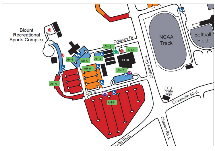
D Zone Lots: Blount Recreational Sports Complex
The Blount Recreational Sports Complex at ECU offers various parking options and facilities for game day.
- Parking Areas: Several parking lots are available, labeled AH-1 through AH-9. The lots are located throughout the complex, with AH-8 being the largest, positioned near the southern boundary. All parking areas are color-coded in red for easy identification.
- Accessible Parking: Designated accessible spots, indicated by wheelchair symbols, are located near multiple parking areas to ensure easy access.
- Buildings and Facilities:
- Several buildings are located within the complex, represented by different colors (orange and blue). One of the main buildings is Belk, situated near the center of the area.
- To the east, you’ll find the NCAA Track and the Softball Field, which can be used as landmarks for orientation.
- Streets and Navigation:
- Curry Ct. runs through the middle of the complex, connecting several parking areas.
- Oglesby Dr. is located in the northern section, providing access to nearby facilities and parking.
- Charles Blvd. and Greenville Blvd. outline the complex, serving as major roads for accessing the parking lots.
Athletic Complex Lots
The Athletic Complex Area at ECU offers various parking options and facilities around key sports venues:
- Parking Lots:
- The parking areas are labeled AC-1 through AC-11, with most lots situated along Ficklen Dr. and the surrounding areas. Lots are color-coded in orange for easy identification.
- AC-10 is a large lot located south of Dowdy-Ficklen Stadium, providing significant parking space.
- Several accessible parking spots are marked with wheelchair symbols across various lots, including AC-2, AC-5, AC-7, and AC-9.
- Key Buildings and Facilities:
- The Dowdy-Ficklen Stadium is centrally located, with the Murphy Center and Minges Coliseum positioned nearby.
- To the south, the Clark-LeClair Stadium and Maintenance Building are situated near the southern parking lots.
- A Soccer Field is located to the southeast of the complex.
- Major Roads for Navigation:
- Ficklen Dr. runs along the northern boundary, providing access to several parking lots.
- Charles Blvd. serves as a western boundary for the complex.
- Blackbeard’s Alley and Fieldside Dr. provide additional access to the area, circling the stadium.
B1 Lots: ECU Campus Hill Parking and 14th Street
The Campus Hill (CH) parking areas include multiple locations near Tenth Street and Fourteenth Street:
- Primary Parking Lots (CH-1 to CH-4):
- Located near the intersection of Tenth Street and Spring Hill Drive.
- CH-3 is the largest lot, situated just south of Tenth Street.
- Accessible parking spots are available in CH-2 and CH-3, marked with wheelchair symbols.
- CH-4 is accessible via Spring Hill Drive.
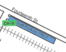
- Additional Parking Lot (CH-11):
- Located along Fourteenth Street, this lot is marked as “Staff Parking ONLY.”
- Access and Navigation:
- Tenth Street provides access to the main Campus Hill parking lots (CH-1 to CH-4).
- Fourteenth Street runs along the northern boundary of CH-11.
- Spring Hill Drive connects to CH-4 from Tenth Street.
- Additional Features:
- Emergency call boxes, indicated by blue light symbols, are located near some parking areas.
- Bus stops are marked, offering nearby public transportation options.
A1 Lot: Christenbury Gym/Brewster Building
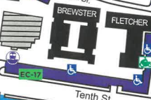
The EC-17 parking lot is located along Tenth Street, near the Brewster and Fletcher buildings:
- Parking Features:
- The lot provides accessible parking spaces, clearly marked with wheelchair symbols.
- Nearby Facilities:
- The Brewster and Fletcher buildings are adjacent to the lot, making it convenient for visitors to these locations.
- Access and Navigation:
- Tenth Street runs parallel to the lot, offering easy access.
- Additional Amenities:
- A bus stop is situated nearby, providing a public transportation option for reaching the lot.


